GNW Extends Forest Concession Coverage by 34 Million Hectares, Adding Important Context to Forest Monitoring
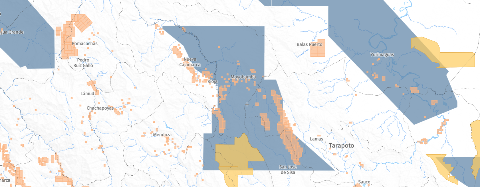
GNW map showing concessions in Peru
Forests remain under sustained pressure from agricultural expansion, infrastructure development and resource extraction, making it essential to understand where and why forests are changing and how to mitigate the impacts of changes driven by these activities. Satellite data has transformed our ability to monitor changes in forest cover, but understanding the activities directly driving these changes and whether they are authorized requires additional context.
To help provide this context, Global Nature Watch (GNW), formerly Global Forest Watch, recently updated our concession data. Concessions are government-issued licenses to companies or the public to manage public lands for defined activities. For some countries, the data provides information on who holds these rights, what type of activity is allowed, and for how long, helping us connect patterns of forest and other natural ecosystem change to the policies and industries shaping them. Open and accessible concession data helps governments, NGOs and local communities see what may be driving land change and whether the change was authorized. This is the foundation for sound natural resource management and governance.
Since 2014, GNW has hosted map layers for five concession types that drive tree cover loss: logging, mining, oil palm, oil and gas, and wood fiber. These concession maps were last updated in 2021; however, over time, sources became outdated and better documentation was needed to track updates to these boundaries.
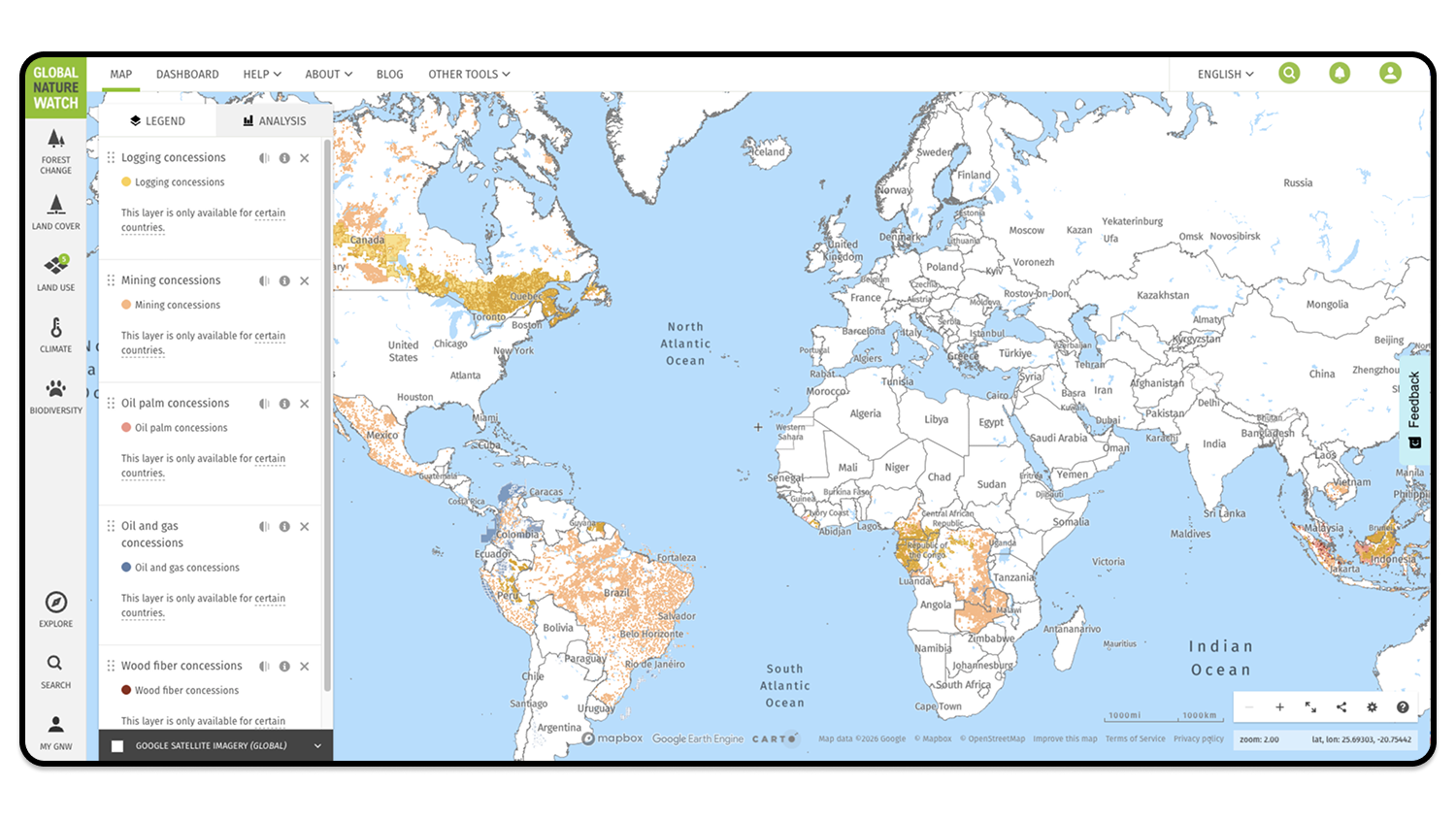
Now, we’ve updated the five concession map layers by adding 34 million hectares — equivalent to the size of the Republic of the Congo — of new or updated boundaries across 12 countries, as well as adding improved attribution and documentation. The updated maps allow users to better monitor the impacts of commodity demands on our world’s forests, help stakeholders avoid conflicting land use allocations and support community-led monitoring.
What’s new with the GNW concessions data?
The five concession map layers were originally launched on GNW in 2014, and were created by consolidating national concession boundaries into a single dataset per type of concession. Boundaries were sourced by searching government websites as well as websites of other NGOs that compile and/or host concession data. We focused our search within priority geographies for tropical forest conservation but opportunistically included data outside of these geographies where it was easily accessible. The sources often included key attributes — such as the company name or entity, status and source — that we retained in the map layers.
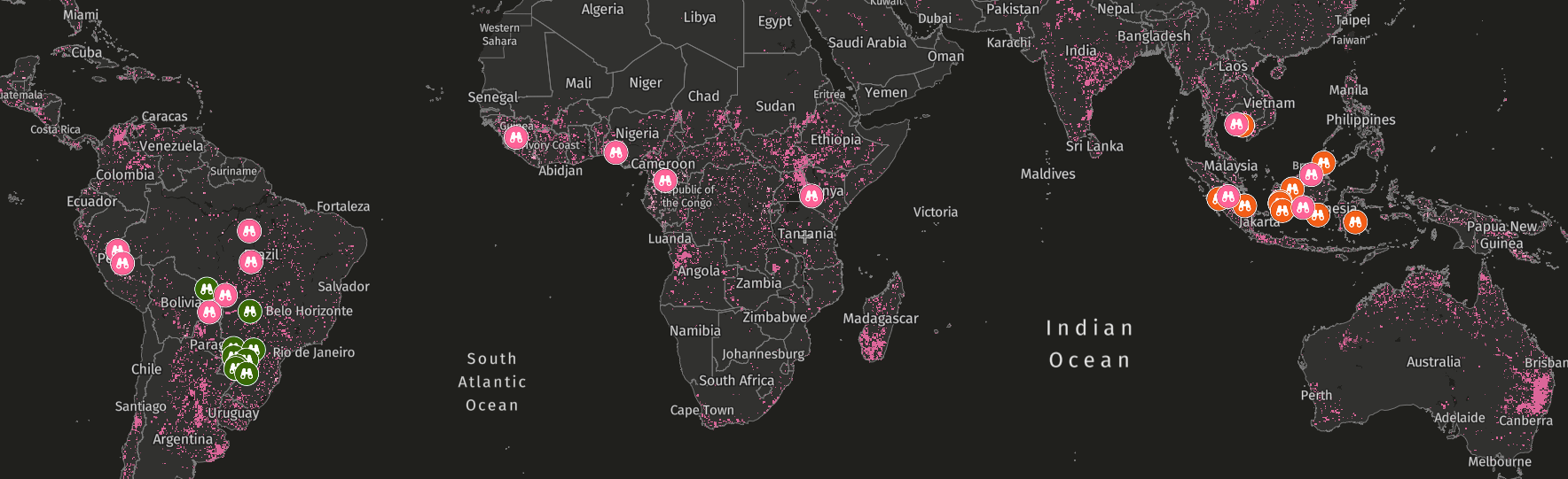
The latest update, completed in 2025, includes a significant refresh that updated or added concession data across a total of 12 countries (see map below), with source dates up to 2025. This refresh added 34 million hectares of allocated concession lands across all five layers and brings the total coverage to 21 countries. The attributes — additional details for each concession — were also standardized and expanded to ensure all concession layers include the following, as available:
- Type of legal contract being executed (e.g., exploration permit, exploitation license)
- Contract IDs or permit numbers
- Parent company or corporate group associated with the concession holder
- Date the concession begins and ends
Attributes specific to the concession type, such as block numbers in oil and gas concessions, are also included. Each attribute name is standardized across all five layers to help users compile this information across concession type, and each download file includes an attribute key.
Source documentation is now also linked in each respective metadata page along with the year the source was last updated.
How can the updated data be used?
Open and accessible concession data supports forest monitoring and management by making boundaries visible and verifiable. The data provides supportive evidence that civil society groups, journalists, law enforcement agencies and due diligence processes need to hold actors accountable for environmental impacts within and around concession areas and enables participation by these groups in compliance monitoring.
This is particularly relevant under the EU Deforestation Regulation (EUDR), which requires companies to trace regulated commodities back to the plot of land where they were produced and confirm production didn’t cause deforestation after 2020. While concession data alone cannot prove illegality, it can be used alongside other information, such as permits or management plans, to build a robust evidence base.
Additionally, the data supports better land-use planning, particularly at the national level, by helping governments create one comprehensive land-use map that incorporates concessions and other land-use layers across different ministries. This helps both governments and other stakeholders avoid conflicting land uses and land claims.
However, it is important to note the limitations of the concession maps:
- They do not indicate whether a land allocation was legally obtained, nor if the activities within it comply with other relevant laws and regulations.
- They do not indicate if an allocation is free of land use conflicts, such as overlaps with other allocated land uses including protected areas or Indigenous land claims.
- They do not guarantee that the land is actively being used for a designated activity.
- The data can include imprecise boundaries, and coverage can be uneven across countries and commodity types.
- The status of concessions can change quickly (e.g., from active to non-active), and it may take time for these changes to be reflected within official sources (note that inactive or expired concessions, as defined by the source, are excluded from concession layers on GNW).
- On GNW specifically, concession extent is limited to prioritized geographies and where spatial data is publicly available, and therefore it does not include coverage across every country.
- Not all map sources included have been provided or approved by a government entity. The compiled maps are our best assessment of concession extent using both government and non-government sources.
This underpins the importance of using concession data alongside other supporting information such as permits, court decisions, satellite imagery or field verification, particularly in cases of enforcement.
Examples of concession data in action
Verifying causes of deforestation alerts in Indonesia
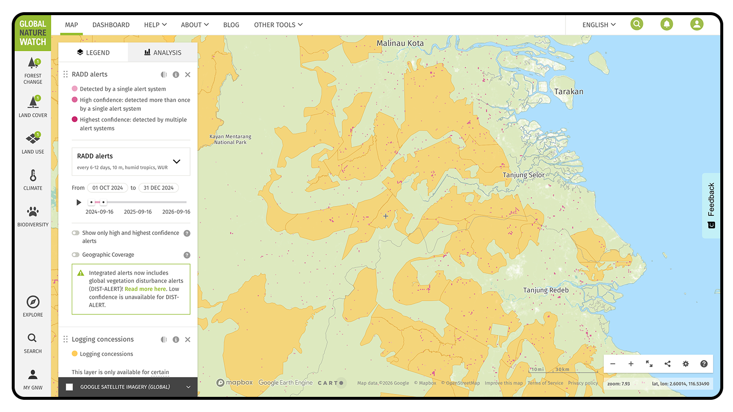
The Landscape Monitoring Initiative was a collaborative project led by WRI Indonesia aimed at advancing forest monitoring and deforestation interventions across three Indonesian provinces. In this project, radar-based deforestation (RADD) alerts were monitored and investigated across pilot jurisdictions to better understand where and why forest loss was occurring. Concession holders were responsible for monitoring and verifying activities within their respective areas by intersecting RADD alerts with their own concession boundaries.
In Bulungan Regency, one of the pilot jurisdictions, RADD alerts were identified within logging concessions. While some tree cover loss is expected from the concession holder’s authorized operations, additional verification is needed to confirm whether the loss is indeed part of the operations or due to other drivers. During the verification process, some alerts within the logging concessions were found to be driven by communities practicing shifting cultivation or permanent agriculture, rather than by the concession holder’s operations. This information allowed the Forest Management Unit to take appropriate action, including notifying the village administration of the loss and socializing relevant forest area management policies.
Assessing concession impacts on Saamaka land rights in Suriname
The Saamaka are an Afro-descendent tribal community living in Suriname’s Amazonian rainforest. In 2007, the Inter-American Court of Human Rights ruled that the government of Suriname must recognize the traditional land rights of the Saamaka and other Indigenous and community groups, requiring their approval for future projects on their lands.
In 2023, a logging company began bulldozing a road through the Saamaka’s forest. The development of the road was sanctioned within a logging concession by the government but did not have the Saamaka’s approval. The community used logging concession data on GNW to gather evidence that tree cover loss was increasing in their lands since 2007, driven by logging and mining activities. They found that tree cover loss inside government-granted logging concessions in and surrounding their territory totaled 44,700 hectares, or a 5.5% loss in tree cover from 2001-2022.
Representatives from the Saamaka territory and other Indigenous and local communities in Suriname brought this data to the Inter-American Commission on Human Rights in November 2023 as supportive evidence for reopening the case against the Suriname government and strengthening the traditional land rights afforded to them 16 years prior.
Where can I find the concession data and what’s next?
Users can access the concession layers on the Global Nature Watch map and on the WRI Data Explorer. Concession boundaries can be analyzed on-the-fly alongside key forest monitoring datasets, and users can download each concession type layer for further use.
Going forward, we plan to update the concessions data annually to ensure GNW continues to offer the most up-to-date concession boundaries available. Concessions are currently available across 21 countries, but efforts will continue to expand coverage, particularly in primary tropical forest countries such as Bolivia, Ghana, Myanmar, Nigeria, Paraguay, Thailand and Vietnam.
In the future, concession layers will also be made available on Horizon, GNW’s AI-enabled platform currently in preview, further promoting open data access and expanding analysis capabilities.